🐕 DOG-FRIENDLY — Pine Valley Mountain Loop, Dixie National Forest, Utah
Score: 88/100 — Great Day to Go
46°F at the trailhead. Feels like 37°F. Wind at 8mph, gusts to 14. AQI is 34 (Good). No fires within 50km — nearest is 170km out, low risk across the board.
The site's best months listing for Pine Valley Mountain Loop is July through September. Today is April 21st. The score is 88. Those two facts require some reconciliation.
---
What 88/100 Means in April on a July Trail
The Pine Valley Mountain Loop is a 35-mile, 5,200-foot-gain backpacking circuit through one of the most undervisited wilderness areas in southern Utah. It's hard-rated, multi-day, AWD access recommended, and it sits in a zone that officially enters its best conditions in July when the upper elevation snow has cleared and the days are long.
But right now it's scoring 88 out of 100. That score is based on actual conditions: temperature is manageable, no precipitation risk, no fire risk, excellent air quality. The mathematical case for the trail being good today is sound.
The nuance is that the best-months window is about more than temperature and AQI. At 10,000+ feet elevation in the Pine Valley Mountains, April means snowpack on north-facing slopes. It means the upper loop sections may have snow-covered trail. It means you'll need navigation skills that a July hiker following a clear beaten path doesn't need.
88/100 is accurate as a conditions score. Go in knowing what conditions you'll find.
---
What the Trail Is
Pine Valley Mountain Loop is a 35-mile circuit around the Pine Valley Mountain Wilderness in the Dixie National Forest, about 30 miles north of St. George, Utah. Most people don't know this wilderness area exists, which is the first interesting thing about it.
The loop gains 5,200 feet over its circuit, reaching elevations above 10,000 feet. There are no established campsites — this is a Leave No Trace wilderness area, and you're selecting your own camping spots. The trail is lightly maintained and lightly traveled, which means navigation is part of the experience. In July and August, that's mostly fine. In April, with snow obscuring sections of trail, you need a GPS track and the skill to follow it.
The wilderness area is dense with ponderosa pine, aspen, and fir at elevation, and transitions to scrub oak and sagebrush on the lower flanks. Wildlife sightings — deer, pronghorn, sometimes elk — are common in the early morning on the upper sections. It's genuinely remote in a way that the popular Southern Utah corridor (Zion, Bryce, the Narrows) isn't.
35 miles with 5,200 feet of gain is a 3-day minimum for most people. Give yourself 4 to do it properly.
---
Today's Conditions in Detail
At 46°F with a 37°F feels-like and 8mph wind gusting to 14, you're dressing for cold and wind at the trailhead. At 10,000 feet elevation on the upper loop, subtract another 5-7°F from that. The effective temperature on exposed ridgeline sections today is in the low 30s.
That's not dangerous for a prepared backpacker. It's cold. Bring layers that account for camp temperatures that will drop into the 20s overnight at elevation in April. A sleeping bag rated to 20°F is appropriate for this trip in April. Kelly looked at the 10-day forecast this morning and added a down puffy to the kit she was already planning to bring. She was right to.
The AQI at 34 (Good) means clear visibility across the wilderness area. The upper sections of Pine Valley Mountain have views northwest toward the Nevada ranges and south toward the Arizona Strip and the Grand Canyon plateau. With AQI this clean, those views will be what they're supposed to be.
---
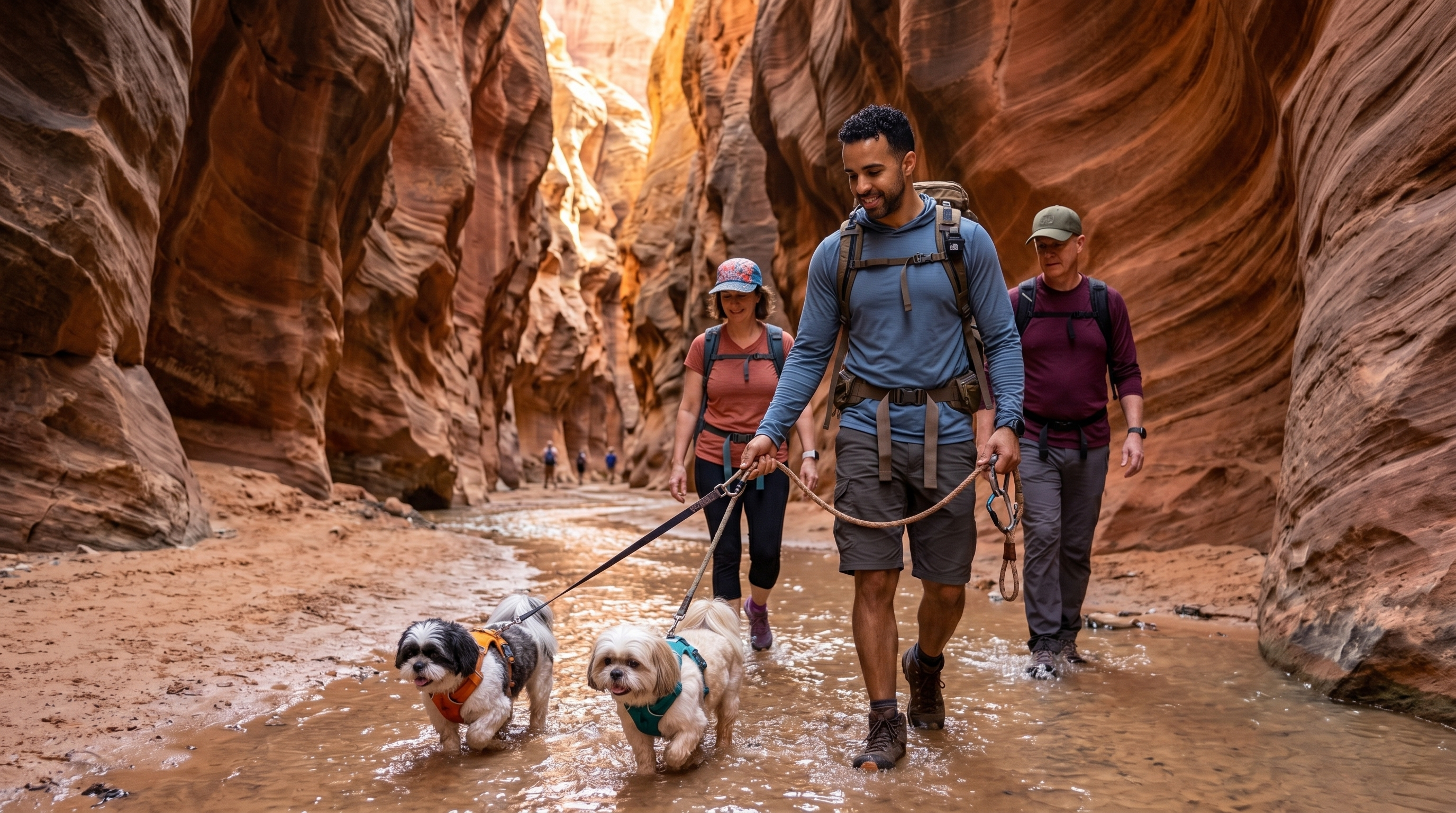
Kelly and Mark on the Upper Loop
Pine Valley Mountain Loop is dog-friendly, and I've been planning this one for a while. The lower sections of the loop are manageable for small dogs — the terrain is gradual and the trail is reasonably clear. The upper sections are a different story in April.
The realistic assessment for Kelly and Mark: They've proven they can keep up on anything within reason. The Garden of the Gods in 38°F last weekend, no problems. The question for Pine Valley Mountain isn't their stamina — it's the snow.
If the upper sections have significant snow coverage, dogs are post-holing where hikers can use microspikes and redistribute their weight differently. Small dogs in snow are post-holing in snow that comes to their chests. That's exhausting in a way that affects your pace and their enjoyment of the trip considerably.
My plan: Start the lower loop, assess snow coverage at the first 8,000-foot section. If the snow is manageable (less than 6 inches, solid crust), we continue. If it's deep and soft, we call it a day-and-a-half loop on the lower sections and save the upper circuit for July.
This is the honest version of bringing small dogs into April wilderness conditions. Sometimes you go, assess, and modify. That's not failure — that's calibration.
General dog notes:
- Leash required in Dixie NF wilderness areas
- Water available from streams in the lower sections; carry 2L minimum through upper sections where water sources may be frozen
- No established campsites — any flat clear area away from water sources and trail is appropriate
- Bear box or hang your food; there are black bears in the Pine Valley Wilderness
---
Access
AWD recommended. The access road to the trailhead approaches from the town of Pine Valley via UT-18. The last section is unpaved and can be soft after winter precipitation. In April, there may still be frost heave on the access road surface that makes two-wheel-drive vehicles struggle. Call the Dixie NF Hurricane Ranger District (435-652-3100) for road conditions before you commit to the drive.
The trailhead parking area is small — arrive early on weekends in April or you'll be parking on the access road.
---
The Permit Question
Currently no permit required for the Pine Valley Mountain Wilderness. That will likely change as the area gets more visitors — the Recreation.gov permit system has been expanding to more Southwest wilderness areas every year. As of April 2026, you can go without booking. Enjoy it while that's true.
---
John's Take
88/100 in April for a July trail is a conditional green light. The conditions are genuinely good for a prepared party. The snow coverage on the upper loop is the variable that a conditions score can't fully account for — check in with the ranger district, download the GPS track, and make the call to continue or modify on the ground.
What I can say is that right now, the weather window is real. No fire risk, no rain, temperatures that are manageable with the right gear. The wilderness is effectively empty in April — you're unlikely to share the upper loop with more than one or two other parties. That's the trade for the extra preparation.
Kelly and Mark will figure it out on the first snow section. I'll report back on whether we made it around the whole thing or got persuaded to call an audible.
---
_Conditions current as of 2026-04-21. Check the live score at alwayshave.fun/trail/pine-valley-mountain-ut before heading out. Upper elevation snow coverage not reflected in score — call Dixie NF Hurricane Ranger District: 435-652-3100._
📍 Live conditions for Pine Valley Mountain Loop →