NO DOGS — Delicate Arch, Arches National Park, Utah
Score: 90/100 — Great Day to Go
64°F at the trailhead. Feels like 60°F. Wind is 8mph out of the southwest — noticeable but not the kind that's going to push you sideways on the slickrock. AQI is 22 (Good). No fires within 50km. Nearest fire is 180km out.
This is genuinely a great day to be at Delicate Arch. Late April sits right in the window before Moab summer turns into something that requires survival planning — mid-May through September out here is a different hike than what you're signing up for today. 90/100 is the score. The main friction point is logistics, not conditions.
Riley stays home. Arches National Park does not allow dogs on trails. I'll say more about that.
---
What You Need Before You Leave the House
Timed Entry Ticket: Arches National Park requires timed entry reservations from April 1 through October 31. Without a reservation, you cannot enter the park during timed entry hours (6 AM to 5 PM). Reservations open 30 days in advance on recreation.gov. If you're reading this the day before your trip without a reservation, your realistic options are: arrive before 6 AM to get in on an early morning window, or plan your visit for after 5 PM (sunset timing at the arch in late April is around 8:15 PM — the light is actually better in the evening).
The Dog Situation: No dogs on trails in Arches National Park. The rule is enforced and the park is serious about it. Dogs are allowed in parking lots, on paved roads, and in the campground on a leash — but not on any trail surface. Riley has done enough of the Southwest to know that Arches isn't his day. I don't bring him, he doesn't give me the look, we both pretend this is a normal arrangement.
If you're traveling with a dog, your options are: bring someone who can wait at the trailhead/parking area with the dog, use a boarding service in Moab, or pick a different trail for this trip. I've done all three. Leaving someone at the Wolfe Ranch parking area with a dog is actually not the worst setup — there's shade in the morning, the ranch ruins are a short walk from the lot, and the dog gets some stimulation without the full 3-mile commitment.
Water: Minimum one liter per person. Preferably two. There is no water on this trail. In 64°F weather, most people underestimate how much slickrock hiking in direct sun pulls out of you. The trail is fully exposed for the entire climb.
---
The Trail
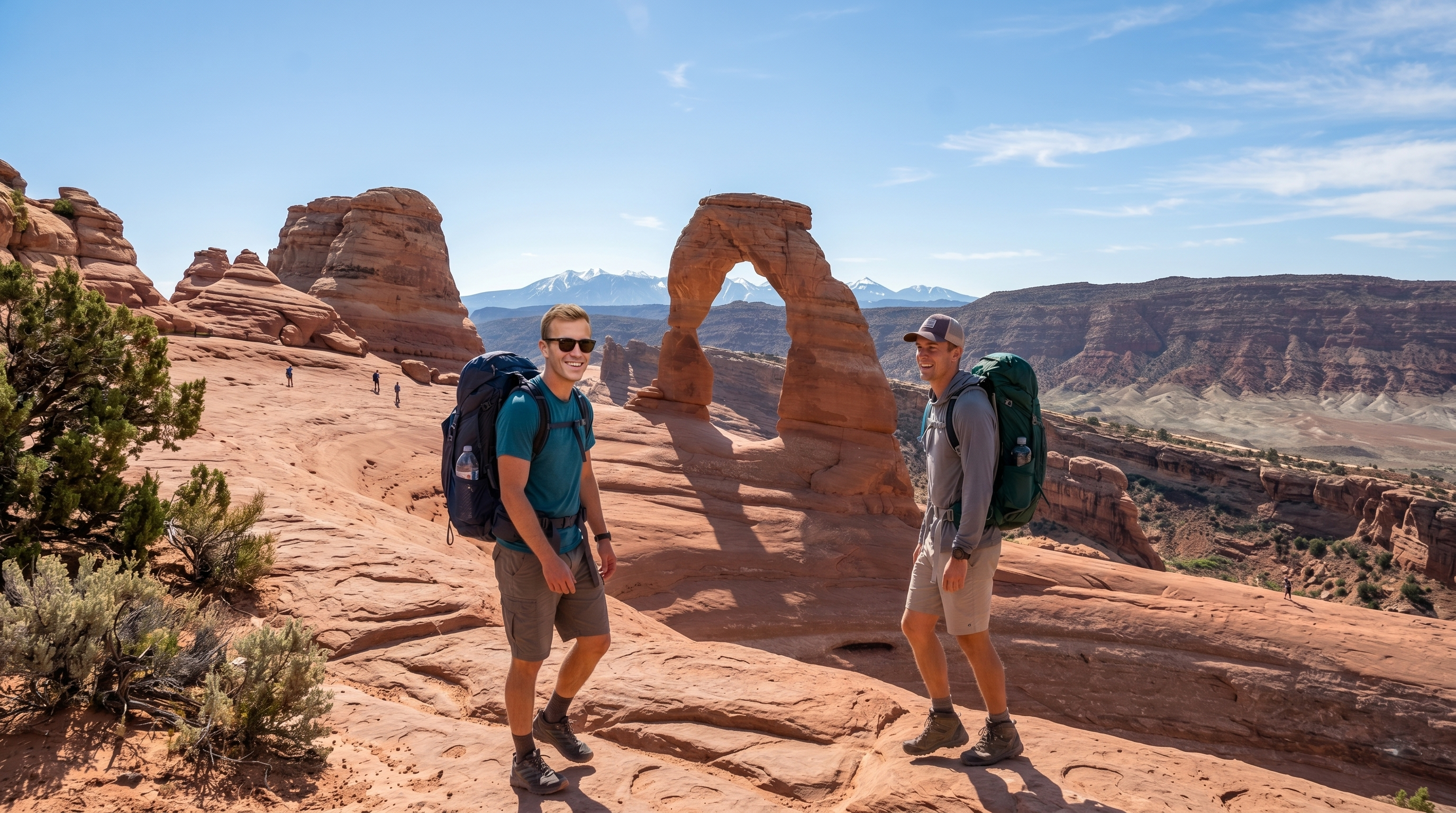
Delicate Arch is 3.2 miles round trip with 480 feet of elevation gain. It starts at Wolfe Ranch (there's a Civil War-era homestead cabin and some Ute petroglyphs near the trailhead — worth the 2 minutes to look) and climbs up a series of sandstone slickrock fins before crossing a narrow exposed section and rounding the final ledge to the arch.
The route is marked by cairns across the slickrock sections. The cairns are clear enough that route-finding isn't a serious issue in good visibility. When it's windy or rainy, or if afternoon thunderstorms roll in, the slickrock can get complicated. Today is 8mph wind and no precip chance — you're fine.
The ledge: About a half mile before the arch, there's a ledge section with significant exposure to your left and a rock face to your right. The trail is wide enough that most people don't find it scary, but if you're bringing kids or anyone with height anxiety, it's worth knowing it's there. The drop-off is real. No scrambling required — it's a walking trail — but the exposure is genuine.
The arch bowl: The trail comes around a final bowl of sandstone and Delicate Arch appears at the far end. This is the money shot, and yes, it looks like the postcards. The bowl is big enough that even on busy days you can get some space from other groups. In late April at 90/100 conditions, expect other people — this is one of the most visited trails in the most visited national park in Utah. Arrive early or late for the thinner crowds.
---
Why This Score Is 90
Late April is genuinely the sweet spot for Delicate Arch. Here's the breakdown:
Temperature (64°F): This is the ideal range. The slickrock amplifies radiant heat, so actual felt temperature on the exposed sections runs about 5-8°F warmer than the air temp. 64°F air temp means you're hiking in 70-72°F effective conditions — comfortable for a sustained effort without the dehydration risk that kicks in above 85°F air temp. The climb back down is typically warmer than the climb up; you'll feel this.
Wind (8mph): Negligible. The sandstone terrain creates its own wind channels and you'll feel gusts intermittently on the exposed sections, but 8mph is below the threshold where it becomes a navigation consideration on slickrock. The arch bowl itself is often calmer than the surrounding terrain because the rock walls redirect airflow.
AQI (22, Good): Clear visibility. The La Sal Mountains to the southeast will be crisp. The canyon country views from the bowl are at their best in this AQI range — no haze, no fire smoke, no dust event diffusion. The photography is going to be good.
Fire risk: Low. No active fires within a significant radius. Arches doesn't have much vegetation to carry fire, but the smoke from regional fires can travel and affect AQI with no local fire present. That's not a concern today.
The 10-point deduction: Timed entry reservation logistics are not a condition issue — the trail and weather are both excellent. But the friction of needing a reservation, and the potential for crowding once you're in the park, pushes the practical day score off a perfect 100. The trail itself is a 100 day. Getting there and parking is a 78 day. 90 splits the difference.
---
Practical Info
Trailhead: Wolfe Ranch Trailhead, Arches National Park. 18 miles north of Moab on US-191, then 12 miles into the park on the main road. The Wolfe Ranch parking lot is large but fills early on high-traffic days. Peak parking pressure is between 9 AM and 2 PM. Before 7:30 AM or after 4 PM is more forgiving.
Elevation: 4,329 feet at trailhead, 4,829 feet at the arch. The gain is gradual — there are no sustained steep sections, just consistent uphill slickrock travel.
Difficulty: Moderate. The slickrock sections require balance and attention to footing, particularly on the way down when knees are tired and the surface gets slippery if there's any moisture. Most reasonable adults in moderate fitness can do this comfortably. It's not a casual stroll, but it's not technical hiking.
Time: Allow 2-3 hours for the round trip including time at the arch. The arch itself deserves at least 20 minutes — circumnavigate the bowl, find your angle, watch how the light moves. Don't just photograph it and leave.
Best time today: Based on 64°F/AQI 22 conditions and an 8:15 PM sunset: morning arrival (7-9 AM) for cooler temps and softer light; or late afternoon arrival (4-6 PM) to catch the pre-sunset light on the arch, which is worth every traffic and parking headache you'll deal with to get there.
Gear: Trail runners or light hikers. Poles are helpful on the descent for anyone with knee issues. Sun protection is non-negotiable — hat, sunscreen, and sunglasses on fully exposed slickrock. Layers for the morning start (it'll be in the low 50s°F at 6 AM before warming to today's forecast high).
---
After the Hike
Moab, 18 miles south, has everything you need. Moab Brewery is the obvious move for anyone who wants to decompress with food and beer. The Deli at Moab is a better call for sandwiches before the hike. If you're camping in the park at Devils Garden Campground, you're already set.
The petroglyphs at the Wolfe Ranch site are easy to miss — they're a quarter-mile round trip on a signed trail just south of the main trailhead. Ute rock art in reddish sandstone, attributed to the Ute tribe dating to the 1650-1850 period. Take the detour.
---
Score Summary
| Metric | Value | Rating |
|--------|-------|--------|
| Temperature | 64°F | ✅ Excellent |
| Wind | 8 mph | ✅ Good |
| AQI | 22 (Good) | ✅ Excellent |
| Fire Risk | Low (180km) | ✅ Clear |
| Trail Status | Open | ✅ |
| Timed Entry | Required | ⚠️ Plan ahead |
| Dog Friendly | No | ❌ |
Overall Score: 90/100 — Great Day to Go
---
Conditions data updated via Open-Meteo, AirNow, and NASA FIRMS fire database. Trail status sourced from NPS Arches road/trail conditions. Check the live conditions dashboard for real-time score updates before you leave.